I am hoping to walk the high peaks and create a hiking route from the southern end of PHuket at Laem Prom Thep to the bridge which forms the northern point at Sarasin bridge. The crow flies this route in only 30 miles, but i expect my trail, when finished will be about 100 miles. Phuket comes from a Malaysian word Bukit meaning mountain, as it is very mountainous. IT will be a tough trail through a lot of rubber plantations and thick jungle. The mountains are very steep sided here as much of the landscape in Thailand. And many places have been stripped even more of their sides from the tin mining that went on here 40-70 years ago. Anyway……….
I started at Big Buddha about 2 weeks ago and have gone out about 5 times now and today reached the top of the mtn that has the big golf ball looking thingy on top. (name on Google Earth is: Khao Mai Sip Song) It is some kind of military radar and when i got there, found out it is restricted area.
Anyway, i hope to explain some of my bushwhacking and trailblazing here in my blog along with my files from my GPS and Google Earth which i use both a lot to find the best ways to bushwhack and use exsisting clearings, creeks, dirt roads and paths through rubber plantations etc. I could do it without the two combined as it is very steep terrain sometimes and very thick jungle. 
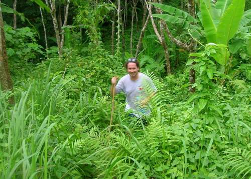
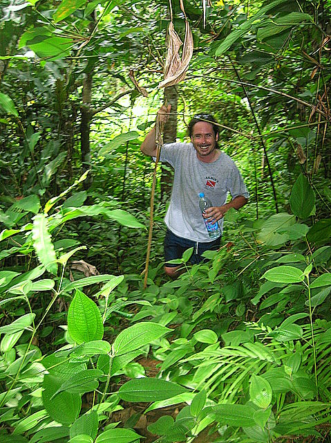
So, today (Tuesday Aug 12/2008) I went out with Ricky (our drummer in the band here) as he said he likes hiking and finally agreed to go with me. We put a motorcycle at the other end and drove together on one to the start near the Big Buddha. I set up my GPS with the waypoints i would need lined up, fresh batteries and we started.
We headed out from the road junctune near the Big Buddha where a dirt road that leads to many rubber plantations turns left off the main road near a small hut there. (I will Gps this point next time i go up there for reference on my Google maps) In the beginning I was talking a lot and i missed the first turn near a beautiful view of Chalong at a clearing about 200-300 meters into the hike. Had to backtrack a bit to make the left turn on a slightly lesser road. Then we did the ups and downs and turns until we got to another seaview spot where Ricky also was surprised as I was on my first trip up there that Karon beach was on our right instead of our left. This took me 2 days to figure out the first time and there is a family with small kids living around this area where you have to make a hard right turn. I have this marked on my maps as “kids”.
Since i was up there last, the man who i met my first time on this road (day 2 of my earlier trailblazing) has now fixed his road and made it a lot better and wider. This is the man that has the piece of land that i just love. When you finally get to the ridge where his house is, you can look down and see Karon beach on your left and Chalong bay on your right. Both sides are steep but the top is a bit flat so he has a house in the spot where you can easily see both. I picture a huge porch here that i someday would sit at and do my work and look up in either direction and see paradise. This point i named “manu house” in my GPS
Anyway, you only go about another 50-75 meters and there is no more road/trail of any kind. You have to hop a barbed wire fence and are in a new rubber tree field that we walk to the back of and that’s it. The end of easy hiking. Ricky said: What do we do now. Well, i showed him the GPS and told the story of how it took me two days and a lot of exploring before i figured out that we had to bushwhack through some very thick vegetation for only about 20 meters and we were down into somebody elses rubber plantation. He looked at the head high thick grass and then sticker bushes and trees and thick stuff and looked very doubtful at this point. In the exploration, i had to go home, put this GPS into my google earth program and then find another way up (totally different valley) and come up to the point in the lower rubber tree forest. I already had the above spot near the mans house in there and got to where i was only about 50 feet away and bushwhacked up through that thick stuff. So, now we did it downhill and Ricky followed me but i could tell he didn’t like this part.
On the other side of the bushwhack, there were some people right there. A man collecting the days rubber and a woman just behind. Now, whenever i meet someone up there in the mtns, i always say Sawadee Krup and smile and try my best to show them i mean no harm and am just out for a walk. But this time, she saw that we came right from nowhere out of thick jungle brush. She didn’t seem all that happy to see us. Ricky speaks better Thai than me and just told her we were lost.
I then got a little turned around looking for satellites as it was thick overhead jungle cover and rubber trees. I had a few GPS points loaded from past days exploring up there but couldn’t get a signal. Finally i remembered or figured out which way we had to go (more left than straight downhill) and we again had to bushwhack a very short distance to the edge of yet another rubber farm. Now, we had road for a while until we got down to the point that i call “4 way” on my google maps. The road to the right from here takes you down the road that follows a beautiful creek all the way down to where they are building a new golf course near Robs house. I would love to buy some land down there on this road in a beautiful spot i found there with running water nearby.
Anyway, we headed up from there on a little used road. Ricky looked skeptical again and was really hoping we would stay on roads now. We did for a while and then went off on a small path. He asked if i was sure this was right? I said, this is someone’s driveway as there’s a house up here where people live. It was steep and small but sure enough, they were home and remembered me. YOu almost have to go right through their house and they have kids and dogs and i told them i liked their place and hiking around the jungle. They laughed, as Thai people often do. We continued on and now, in my mind, this is the best part coming up. There is a trail although it is a bit overgrown and it winds through some beautiful natural jungle. It is easy to follow but the plants are thick and you need a stick to brush them back.
Once again, i could tell that Ricky wasn’t liking this. He kept asking about snakes. Now in 6 days or so of being up there, i had seen only 2 snakes for sure and one that could’ve been a lizards tail or a snake. I don’t know. Both times they sensed me or saw me and took off the other way just like the snakes back home where i come from so i wasn’t scared of them. But this was Ricky’s first bushwhacking attempt in Thailand and he was thinking snake all the way.
I took some cool pictures of Ricky here and will upload them soon.
 When we got to the next small dirt road after about 1/2 mile or one kilometer of this kind of hiking (my favorite), I told Ricky that i though the bushwhacking was over and it would be all small roads from here to the end. He had a big smile then.
But the walking still was great with total silence and the occasional bird or sounds from above that are most likely birds although i said it sounded like monkeys at one point. We passed a few small shacks that the rubber farmers live in and i took some pictures. The road was getting better and better until it got to the point where it turned onto the road that they tried to build over the mtn to Patong.
BUt the Thais don’t build roads like the western world and when they have to go up a steep grade, instead of putting switchbacks in, they just go straight up. Well that creates two problems: it washes out so easy with big gulleys as the water continues to build all the way down. And it also causes many serious accidents as trucks and buses lose their brakes or they heat up and they can’t stop and they get out of control and people often die. You can see the big big ruts here in the road and i don’t see it ever working this way.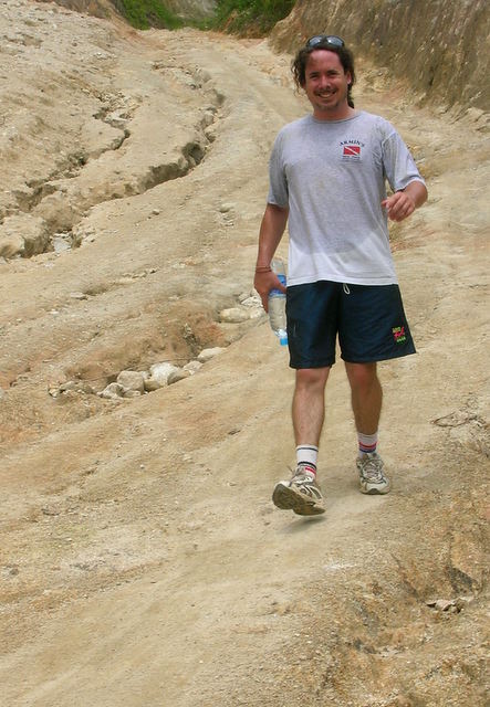
Finally, after passing some great views of Phuket town and Cape Panwa and the bay, we went down steeply to where Ricky’s motorcycle was parked. We then took a good break as we both don’t really like to stop once we get going.
So, that is the first stretch of this trail that i have explored pretty extensively. I still have a change i would like to make near the end where i would go up instead of steeply down and cross over the gap much higher. I have been in there and figured it all out but it is too much bushwhacking for Ricky’s taste and we didn’t have the motorbike set up for the shuttle that way. I will go in some day and try that again and get a track on it for the google earth and gps files I am building for this trail.
For now, i will stop here and continue another blog entry for the next leg. Stay tuned.
Aug 22, 2008: Time to add a bit as yesterday I completed another section: From the southern point of Laem Prom Thep to the road between Nai Harn and Kata (near Kata Viewpoint)
Hiked down to the point with some friends who were visiting and it sure is nice scenery. There is a Y junction about half-way down in which you should take the right fork as it is a bit easier. I got a little wet at the bottom as i was trying to set my GPS to start tracking and wasn’t watching the waves.
After i got up to Laem Prom Thep where all the people hang out on top, i walked down the steps and across to the far left souvineer shop up there and there is a small parking lot just to the left (north) of that. At the extreme left side of that parking lot (once again north) there is a small trail that starts out there and then turns into a small road in the woods. Take that way down and save yourself some bushwhacking from the small trail in back of the parking lot.
In no time at all, you are down and inside a barbed wire fence to the Nai Harn Bungalows. I went right through their bungalows and down through a garden of someone and eventually hit and crossed the road from Ya Nui Beach to Rawai. Up the other side and after about 100 metres, it got pretty thick so i crossed the road here and bushwhacked up to the govt property where the windmill is. Then across the road and down the dirt track to the football field just below. Then just to the right of the 4 wheeler track and found a path in there which i followed to a boundary marker and stuck to the edge of a rubber tree plantation.
Pretty easy hiking along trails and boundaries down to a cell phone tower and then steeply down to the lake at Nai Harn. Good Stuff.
From here, i crossed the bridge near the Reggae Bar and went up the steep dirt road at the corner near the old Laguna bar. At the top were some Thai’s playing that volleyball looking game with their feet. They were excellent and had a nice spot up there. I said a few words about the Olympics right here in Thailand and continued my ascent. It kept going up and up for a long time. Once again, i followed the edge of fields and rubber trees and went from boundary to boundary. Eventually there is a path up there that is fairly easy to follow. Then a bunch of turning and twisting always heading for the top. A little bushwhacking but not much as there are lots of old trails almost like game trails.
At the top is a clearing that i marked cleara on my gps. From there there were 4 wheeler tracks and roads and it got better and better. I was always very close to the line on my GPS from my route i planned out on Google Earth. I finally saw the road and called Tony who lives nearby to get a ride back to my starting point. Found an Aussie dollar (bronze coin) up there on the road too.
All in all, this was a beautiful day and great hike. I hope to take Kim up there one of these days and show her how close we live to getting away from it all and a nice (though somewhat steep) hike.
Stay tuned once again for more. It’s raining today so i’m not going out but will again soon.

Aug 24, 2008
Went out again today to do the section from where i left off near Kata viewpoint (where the road goes over the mtn between Kata and Nai Harn (route 4233 on Google Earth) over to the road crossing at Kata hill (4028 between Chalong and Kata Center)
It was a beautiful day and the hike started out great with an old road to follow for about 100 metres or so. Then it was back to climbing through newly planted rubber trees and pretty easy to see where i needed to go. (i always try to follow the highest point and the ridgeline) Went up and up and finally it was just the ridge and jungle and a little bushwhacking although pretty easy as it wasn’t too thick.
Then i got to a small road which lead north on the ridge for only about 200 metres until it came to a big road that was all grey stone and in great shape.
Now, i didn’t know there was a road up there and this one was well maintained. I followed it slightly and then it seemed to go down so i went back to bushwhacking but found myself in a clearing of a rubber plantation with 2 big dogs that didn’t like me there. So, i returned to the road and followed it for a while.
I came to a shack about 500 metres later and there was a woman taking a bath there and a small track behind her house that appeared to go just the way i wanted. I started up it but she said no no. SO, i tried to explain that i really wanted to go that direction but she pointed the way i had been headed and said go that way. I backtracked to see if i could get around her property but it was a deep gully. Once again I asked and she said NO. SO, i continued on the road and sure enough, it turned the same direction and was a nice walk on a good road. AFter about 2 miles, i started seeing nice houses and knew i was getting closer to Kata. Some very nice views and houses up there.
I finally came out at the Kata road (main road) at a sign saying Inter Hotel just north of the high peak of the road. Looking at it from one of the views, i knew i really wanted to be up about a 1/4 mile towards the top (south) .
Today, i rode my motorcycle up there and tried a lot of different roads and came to a seemingly abondoned beautiful old restaurant that had been called Ban Pla (house fish?) This place had a view that couldn’t be beat looking at both Chalong and Kata beach. But how to get to it?
I think i really need to go back, and go to that woman again and try to go through where i originally wanted to and now that i have that restaurant GPS’d, i will be able to find it from the ridge. It will take me another day i’m sure but it looks like some beautiful rain forest jungle in there and steep. (just the kind of stuff i like) Took a few pictures up there yesterday as it was a beautiful day. 

Here is a man I saw up there yesterday working. Notice the rope on his bundle of freshly cut stakes. I really must learn to speak Thai better as i couldn’t communicate with him well. He might’ve been a Burmese though as he didn’t understand much of what i said in Thai. 
Ok, today is August 25th and i had another great day out there. I did go back to the woman who didn’t want me crossing her property, with hopes of getting her permission today as i did a lot of looking at Google Earth and thinking that there has got to be a way up to the high peaks and not taking that road (too easy) and coming out somewhere near the Pub Pla abandoned restaurant.
But, when i got there, her husband was also there and they both said no. I plan to come back with one of my Thai friends who also speaks English so they can find out and explain to me why not.
So, i decided to go do the last stretch from the Kata road up to the Big Buddha which would complete my first 1/3 (aprox) of the entire island peak trail. (for lack of a better trail name at this point)
I parked just up the road from where i left off and followed a dirt road up about 50 metres to where someone had bulldozed a flat spot with an ocean view probably with hopes of selling it. From there, i had to bushwhack up some steep rocks ending in thick vegetation that was a bit tough but finally got up to another rubber plantation. I usually follow these near the borders if i can as i feel half in civilization but on the edge of the jungle. A lot easier walking and visability through the plantations although this one was a bit overgrown and i don’t think anyone has been up there lately. 

Had no GPS signal as it was very thick trees overhead. I really need to get a better GPS and am looking at them on ebay now. The X models are supposed to really look through the trees with no problem. I finally came to a small clearing and had to sit down for about 15 minutes till i locked into 4 satellites and got a signal. I marked it SMROAD and continued. Up another 50-100 metres and it hit a bigger road i turned left and saw a lot of fresh elephant shit so knew why the road was there.
Sure enough, after a few hundred more metres, i came across an elephant camp with lots of eleaphants and mahouts (their lifelong trainers and companions who steer them with their feet behind their ears and grunt and yell commands) 
They thought i was lost and pointed me toward the road going up (concrete). When i said no, i want to go this way (pointing straight up towards Big Buddha at the top) they said: “oh there are many snakes, including King Cobra!” Well, I’ve been out about 12 or 13 days now and have seen 2 snakes, both going fast away from me and none of them were cobras let alone King Cobras.
As i’ve noticed many times, Thai people are really afraid of Cobras and so have not spent any time in the jungle and it is rare to hear about someone who has been bitten.
So, i continued up through steep rubber tree plantations enjoying great views back towards Kata beach and had to do some short bushwhacks between the different plantations, once in a while getting into some real “rain forest” jungle with the big indiginous trees that are so beautiful.
Finally i heard a sound and saw some orange and it was a monk living in a rustic cabin. I think i scared him as i came out of nowhere. There were about 4 huts there and a small fire cooking a kettle of food. I hung ou a bit trying to talk to them and they let me take some pictures

Turns out they were not too far from the top and the Gigantic Big Buddha they’ve been building up there for the past 5 years that i’ve been watching it and hiking up there via the road. I forget how high it is but can be seen from the southern half of Phuket and has amazing 360 deg. views from it’s location.

